|
Canoeing the Nitinat Triangle
by Jamie Orr
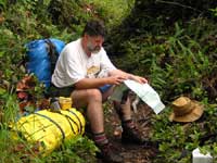
For years I’ve wanted to canoe around the Nitinat Triangle, on Vancouver Island. The triangle involves paddling down part of Nitinat Lake and portaging to two smaller, isolated lakes. For the ambitious, if conditions are right, you can carry on out to the West Coast Trail on the Pacific Ocean and paddle seven kilometres south to Nitinat Narrows, where the lake runs into the ocean, then back up the lake to your starting point.
Our teenage son Alan thought it sounded like fun, so he agreed to fill the forward seat. I hadn’t done any serious camping for some time, but we put together an outfit of sorts and lashed the canoe to the roof-racks.
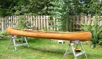
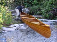
This is a cedar strip canoe a friend and I built in my Calgary days, over twenty years ago. We got the design out of the David Hazen book, borrowed another friend’s garage and used a radial arm saw to cut out the strips. We didn’t bevel or shape the edges of the strips, so we had to use a lot of staples to keep them fair, but everything turned out well. Here’s a picture of her, taken just before this trip.
This is a cedar strip canoe a friend and I built in my Calgary days, over twenty years ago.
(click images to enlarge)
|
|
|
We left Victoria, British Columbia, on a sunny afternoon, taking the highway to the small town of Lake Cowichan, then unpaved logging roads to the eastern end of Nitinat Lake. We camped at the recreation area just past Nitinat Village, sleeping in the van to be ready for a quick getaway in the morning.
|
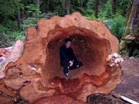
Here’s Alan inside an old cedar log by our campsite.
Too bad it’s rotten, it would have made a lot of canoes!
|
|
We were on the water by 7:30 next morning, and after an easy hour and a half paddle we reached the first portage, to Hobiton Lake. We took Alan’s pack and our “voyageur” bundle consisting of a big dry bag and the tent for the first trip over. It was a rough trail, with lots of climbing. On the second trip, Alan carried the big pack and I took the canoe, tying the paddles inside.
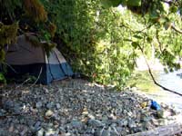
The portage ended at a long narrow bay on the eastern end of Hobiton. We paddled out of this then pulled up for lunch at a gravel bar by a creek mouth. After we’d had a rest we carried on down the lake until we saw a flat area big enough for the tent. The shores are mostly steep, and the trees come right down to the water, the only campsites being where small creeks have carried stones down the hillside, making fairly level, if rough, areas where a tent or two can be pitched. Our site was under an old cedar, with branches hanging down around us.
Our tent under the cedar boughs.
The canoe is behind all that greenery, in a tiny bay.
|
|
|
We took it easy for what was left of the afternoon, cooked and ate a leisurely dinner and went to bed with the sun. Before turning in, we hung the food bag from a high branch overhanging the lake, in case of bears or other critters. I woke once in night to the sound of rain, but it wasn’t heavy, and I was soon asleep again. (I think they call this foreshadowing.)
|
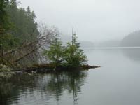
The view next morning, looking east from our camp, back up the lake. |
|
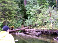
In morning, it was still raining, but lightly. We had a good breakfast, then packed up and paddled off down the lake. As we approached the end of Hobiton, we stayed close to shore, looking for signs of the portage trail to Tsusiat Lake. Found it without trouble, thanks to a faded plastic bag wrapped around a snag. Without the marker, it would have taken some hard searching, as the trail wasn’t visible from the water because of all the old windfalls along the shore.
This is the start of the portage to Tsusiat Lake. The marker is the faded yellow “flag” at the right, level with Alan’s head. We landed where the logs cross.
|
|
|
We carried the bundle and Alan’s pack to the summit of the trail where we found a bog. Who ever heard of putting a bog at the top of a hill? Our directions implied, at least to me, that we had to cross the bog, so we left our loads here, crossed the bog then went all the way around it looking for the trail. Finally found that it bypassed the bog on the same side we started on! We left our packs where they were, and went back down the hill for more. Since this was reputed to be a tougher portage, Alan took half of the rest of our gear while I took the canoe with nothing tied into it this time. We left the big pack for later.
At the summit again, we left the canoe and picked up the bundle I’d carried up earlier, so we had everything we needed to make camp. It was raining steadily now, and we were soaked through despite our rain gear. The trail to Tsusiat Lake is noted on the map as a difficult and boggy portage, and to that you can add slippery logs, dense (and wet) bush and mudholes. At the lake, the bush was too thick to move far off the trail, and the only possible site for the tent was right at the end of the trail, beside the water. I was worried that now we’d stopped, Alan would get seriously cold as he hasn’t got my layer of blubber. I suggested he get inside the tent, strip off his wet clothes and get into his sleeping bag. Meanwhile I made one more trip back to Hobiton for the last pack. When I returned, there was just enough light left to cook a quick dinner before we hit the sack. We left the canoe up on the summit for the night.
That night it rained very hard, the drumming on the tent defied all conversation. We found immediately that the tent had seen better days. The site sloped towards the lake, and the rain running down the higher side leaked in the bottom seam, ran across the floor and formed a miniature lake against the far side. However, the air mattresses kept our sleeping bags up out of the flood and once I stabbed the floor a few times on the low side, the water was able to drain away. We slept well enough until about 3:00 am when we found the lake had risen and wanted to come inside out of the rain. We moved the tent back as far from the water as we could, but that was only about 18”. At least there were no wind and waves.
The leaking tent had the potential to be a real problem, since we couldn’t rely on a dry refuge. If our bedding got wet we’d have serious trouble keeping warm. However, we figured going on or going back would be equally difficult from here, so we decided to carry on.
At 6:00 a.m. it was still pouring, but it was light enough to see the trail and I left to fetch the canoe down from the summit. Although carrying a canoe made negotiating the trail even worse, the canoe itself is light and easy to carry, and I was back by 7:30. We wasted no time in getting the tent down, as about three feet of it was now in the lake. Neither of us wanted to hang around to cook, so we settled for a handful of my wife’s nuclear granola for breakfast. This powerful mixture was a big help over the next two days!
|
This is all that was left of our campsite when we left. The tent was between Alan and the packs at the left. |
|
As we paddled west the rain increased until it was easily the heaviest rain I have ever seen (tropical rain included). I can’t adequately describe it, so I won’t try. Thankfully, by the time we reached other end of lake some six kilometres (four miles) away, it had eased off, and we were able to cook up a proper breakfast in relative comfort. Only our sleeping bags and the food were still reasonably dry, inside their waterproof bags, but we were now only one kilometre from the West Coast Trail, as the raven flies, and we felt pretty chipper despite the wet.
Unfortunately, the trail wasn’t anything like a raven’s flight path. It would’ve almost broken a snake’s back, twisting like a corkscrew through the bush, over logs, under logs and occasionally doubling back on itself. As we crawled, climbed and pushed through, I wondered how we would ever get the canoe over it. We couldn’t tell if it was raining or not, as the wet branches constantly showered us as we brushed against them.
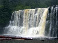
We finally came out onto the West Coast Trail where it crosses the Tsusiat River, right above the falls. These falls are 30 to 40 feet wide, and 25 to 30 feet high, falling straight down to the beach. There are permanent ladders nearby that provide access to the beach, which is a popular campsite for hikers on the trail – there must have been easily a dozen tents spread along the shore. We chose a site among the drift logs and parked our packs, had a quick look at the falls from below then left for the next load, still hoping we could get everything to the campsite that day. However, it took over an hour reach the lake again, carrying nothing, and we realized we weren’t going to make it. Bringing out the second load took another two hours, and the canoe had to be left behind again.
Tsusiat Falls.
Not a great picture, but there was a lot of mist from the falls and I didn’t want to expose the camera to it for long.
|
|
|
Back at the beach it had mostly stopped raining. We took advantage of this to cook up a delicious corned beef hash that brought us back to life. We needed this, as we were both soaked again/still and the inside of tent and the mattresses were wet. We wiped our rain clothes dry and spread them on the damp air mattresses to keep the sleeping bags dry.
We took stock again. We still had a change of dry socks, underwear and fleece vests. We felt that if it rained again, the sleeping bags would probably be unusable another night and our last dry clothes would be wet. We agreed it was time to cut and run, so we decided to leave the canoe where it was and hike out to Nitinat Narrows where we would catch a boat up the lake. So far we had avoided hypothermia, or even being really cold, but things were definitely on a downhill slide.
|
Surf’s up!
Not the best of conditions for an open canoe….
|
|
We didn’t consider fetching the canoe and trying to paddle along the shore. The surf was running high, crashing all along the beach, and our chances of paddling out through it were exactly nil, nada, zip and no way. I won’t even mention the fog and the rocky shoreline between us and the narrows.
We fell asleep to the sound of the surf. In the morning it was still heavily overcast, but no rain was falling. We dressed in whatever was driest and packed away the rain gear. Before we could cook breakfast, we had to bum some matches from a hiker (there were lots of them around us from now on) as our waterproof matches were falling apart. This was a shock -- I’ve never had them fail me before, but both the striking surface (always a weak spot) and the match heads were soft and damp, despite being stored in plastic bags. Should have brought a Bic lighter.
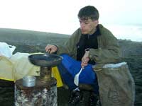
Alan cooking the breakfast bacon on Tsusiat Beach.
|
|
|
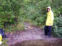
We packed everything up so we could carry it all at once. We started off on the beach trail, but decided the hiking over the soft sand would be too tiring with the big loads, so turned back and went up the ladders to the main trail. Although it went up and down, with a few mudholes and exposed roots to catch unwary feet, this was still like a superhighway compared to our trail the day before.
|
Your correspondent (me).
My load was the pack you see behind me, plus the dry bag in the foreground balanced on top.
|
|
Progress was slow but steady. We were able to measure the distance covered by markers every kilometre, and the weather stayed dry and actually improved some. We got some really weird looks from other hikers, since our bags weren’t at all suited to backpacking, and Alan had a PFD wrapped around his load.
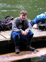
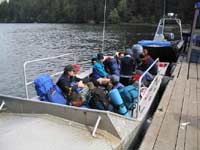
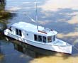
We took 5 ½ hours to cover the 7 kilometres, (4 ½ miles) stopping frequently to rest. The loads were heavy, and awkward to carry. Even so, we weren’t a lot slower than some of the properly-equipped hikers. We kept passing and being passed by one group of hikers all day, until we felt we knew each other quite well! We reached the narrows at 3:30 pm, and sat down to wait for the ferry. This is operated by Carl Edgar, one of the local First Nation people. Carl lives at the other end of Nitinat, commuting by boat and offering water taxi service out at the end of each day. There are always a few hikers who leave the trail at the narrows, (it’s about half way) and numbers were up due to the heavy rain of the last few days. During the day, he and his helper also serve up fresh caught crab and other refreshments to weary hikers. It was great to sit by the wood stove on the float, and know that the work was over.
Despite our trials, we avoided any serious problems. However, there were some lessons learned (or relearned in my case). Our equipment just wasn’t up to snuff. The tent leaked, our matches fell apart and our clothing wasn’t chosen for its ability to stay warm when wet, or to dry quickly. If it hadn’t rained so hard, we’d have been okay, but I should have known better.
I was proud of Alan. He was wet to the skin and had to work like a pack horse on the trails, and when he stopped, he got cold, but he kept going and kept his sense of humour. This was his introduction to canoe-camping, talk about being thrown in the deep end. And I don’t want to leave the impression that we hated every minute of the trip. Parts of it were great, and we found we made a good team. Maybe a little adversity can be a good thing?
We were no sooner home than Alan was talking about going back next summer – the beauty and isolation of the lakes have obviously caught him. But we’ll have a new tent and better clothes for the job, just in case.
Postscript:
Ten days later, Chris Bennett and I made a fast trip in to bring out the canoe, doing the same route in reverse. We went down to the narrows by water-taxi, hiked up the coast and in to Tsusiat Lake. The canoe was just as Alan and I had left it. I hadn’t been too worried about it as few people visit these lakes and the ones that do are probably trustworthy. We paddled the length Tsusiat Lake, then made the portage to Hobiton in a single carry, having limited our equipment so this would be possible. Once we were back on the water we continued part way up this lake before stopping for the night.
In the morning we paddled the rest of the way up Hobiton and portaged to Nitinat Lake, again making only a single trip over the trail, then back to Nitinat Village. We arrived about lunch time, the whole thing having taken us just over a day’s travel from the time the water taxi dropped us off at Nitinat Narrows.
We had great weather all the way – what a difference!
* * *
Here are a few pictures from the second trip:
|
|
|
| This is the Nitinat Narrows ferry, with the water taxi in the background. That’s me in the left front corner. |
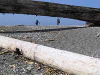
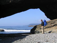
This is a natural rock arch on the beach, a couple of other hikers have just passed under it. |
 |
 |
| Here’s another view of the arch, and myself. |
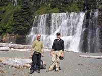
Here’s Tsusiat Falls in the sunshine, with Chris and I in the foreground |
|
 |
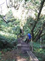
| Here are the ladders to the beach. I’m looking down at Chris from the top landing. |
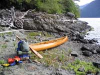
Getting the canoe ready for the trip home. |
 |
 |
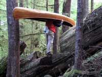
| This is me carrying the canoe over a fallen log on the first portage. You can see where steps have been cut out. |
And we’re back at Nitinat Lake, looking roughly in the direction home. |
|
|