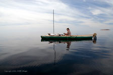
| The winter of 2004 I built my 15'
decked sailing canoe, "Vinta". I spent the
summer of 2005 outfitting, shaking her down and building
different sail rigs. Eventually I settled on a 40
square foot balanced lug. I am primarily a canoeist.
Daytripping is fun but I really enjoy extended camping
trips in the Canadian bush, 2 weeks minimum or longer.
For me, wilderness traveling is the thing, everything
else is just practice. The 100 mile Pukaskwa Coast
of Lake Superior had been on my short list for quite
some time. I now had the boat, I started looking for
other "like minded venturers" to join in
the trip.
None of my regular paddling partners were interested
in Lake Superior. "Too big, too rough, you can't
do that", were their responses. The winter of
2005 I started posting on various canoe and kayak
boards. At one time 7 people were interested, by trip
time it had dwindled to three. Then due to a medical
emergency my good friend, Mick Wood, had to pull out.
It came down to two, an internet aquaintance, Larry
Ricker (NibiMocs, Rochester, Minnesota), and myself
(Indianapolis, In). Nibi didn't have an adequate boat
for the trip and considered renting a seakayak. Luckily
Mick graciously offered one of his Kruger Sea Wind
canoes, a boat eminently qualified for a big water
expedition. We were all set.
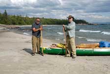
Nibi and I met for the first time July 9th in Wawa,
Ontario. Prior to this we had communicated via the
internet. Larrys' passion is landscape
photography and he provided the photos
for this report. He also is a Boundary Waters specialist,
having made many solo canoe excursions there. Neither
of us had done an extended trip on Lake Superior before.
That afternoon we prepared our gear and discussed
the trip, anxious to be underway. We overnighted in
the lodge at Naturally
Superior Adventures (NSA,), a kayak outfitter
on the shores of Lake Superior at the mouth of the
Michipicoten River. The next morning the wind was
force 2-3 and whipping Michipicoten Harbor into a
frenzy. I tried not to show my trepidation at the
prospect of paddling in those waves. What had I gotten
myself into? At 9:30 our shuttle driver arrived and
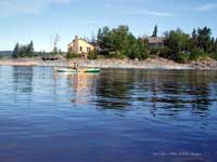
ferried us 100 miles up the coast to Hattie Cove in
the Pukaskwa National Park. Here he dropped us off
and returned my vehicle to NSA.
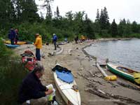 |
Hattie Cove
beach |
By the time we arrived it was early afternoon, cold,
overcast and the wind was force 3 out of the east.
There were two groups of kayakers on the beach readying
their boats and deciding if anyone would "get
out" today. One group was a guided kayak tour
from Naturally Superior Adventures. Hattie Cove didn't
look bad but out on the lake could be a nightmare.
Nibi and I decided to paddle out the cove to at least
check conditions, leaving the kayakers on the beach
wondering what we were up to. Once out and around
Campbell Point there was no turning back. We continued
against 2-3' waves and steady headwinds for a long
two hours until finding welcome refuge in Picture
Rock Harbor. Here we shared a quiet cove with a motorboater
from Thunder Bay who was also sitting out the storm.
Bernie Cline and his dog Hobbes had spent the last
two weeks touring around Superior. They were on the
homeward reach and invited us aboard. We spent a friendly
afternoon chatting and drinking coffee in the cabin.
We camped that night on a small beach nestled against
a stand of pines. The sunset was brilliant.
Distance covered Day 1, 3 miles.
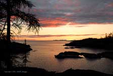 |
Picture Rock
sunset |
The next morning dawned clear, cool and the weather
had settled. We paddled out of Picture Rock Harbor
at 9am and headed south along the coast. There was
only a breath of wind. The first four days were very
hot with cool, crisp nights. The Lake was calm and
the water flat as a pancake; not what I had expected.
It was so hot I often paddled without shirt, using
a bailout jug to pour water over my head. We kept
our course southward down the coast finding secluded
bays with beaches each night for campsites. The scenery
was beautiful, gulls called to us from their rock
islands, eagles soared over the pine clad ridges,
huge granite cliffs and shoals extended into the deep
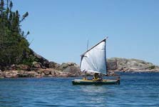
blue green waters. Once I was able to sail a few hours
on a broad reach, ghosting between pink granite outcrops.
But mostly progress was by paddle, the "spruce
breeze".
Distances in miles Day 2, 12.5, Day 3, 15, Day
4, 9.5
 |
Hot and Flat |
 |
sailing in light
wind |
On the fifth day we ventured from behind the protection
of Otter Island. Rounding Otter Head we came face
to face with a changed Lake Superior and force 3-4
winds off the starboard bow. I briefly tried to pinch
upwind with reefed sail but couldn't make headway,
instead being driven onto the cliffs. I had no choice
but to strike sail and paddle. For the next 6 miles
we found no welcome or refuge along the coast. We
were grinding out the miles, stroke by stroke a quarter
to a half mile out. Nibi and I often lost sight of
each other. The swells were head high and occasionally
breaking. It was exciting and quite an experience.
After lunch we landed on Richardson Island and climbed
high to the top of an ancient cobble beach. Centuries
ago, after the glaciers melted, Lake Superior was
much deeper than today. Its decline is recorded in
the terraced beaches. We climbed eight terraces and
a hundred feet up on rocks the size of bowling balls.
At the top we found a group of Pukaskwa Pits. These
pits, which abound in this area, are excavated depressions
in the rocks made by natives centuries ago. Theories
abound but no one knows for sure who actually made
them, how old they are, or for what purpose, whether
lodges, food storage, or spirit quests. The name,
Pukaskwa, is Objibwe for "strange rock formations".
Their existence testifies to the hardiness, strength
and stamina of the primitive indigenous peoples.
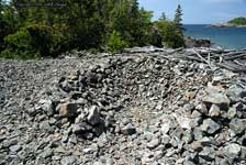 |
A Pukaskwa Pit |
We met the NSA kayakers in the lee of Pointe Canadiane.
It was late afternoon and they had decided to camp
on a rough cobble beach before rounding the point
next morning. Nibi and I were tired, but after a snack
and short rest felt we could round the point and make
camp on nearby Pukaskwa Depot. Pointe Canadiane was
a high point on my trip. Not quite halfway, it stands
one of the most exposed and remote reaches of this
coast. From here we would start heading eastward.
There are no roads or trails leading out to the Point,
the only way is by boat or helicopter.
We made camp that evening on the long sand beach
at Pukaskwa Depot. It's harbor is protected by Davis
Island and in its lee was anchored a large ship. We
learned it's owners, Mr and Mrs Noyes, are a retired
couple who spend their summers exploring Lake Superior.
They now live on Michigan's Upper Pennisula but originally
are from Indianapolis, Indiana, my home town. What
a small world.
Day 5, 11.5 miles
The Depot was a busy place in the 1800's. Many hardy
souls lived there year around. Logs were brought down
the rivers and rafted up in the harbor before being
floated south to be cut into lumber. As the forest
was harvested the Depot became a fishing camp and
when the fisheries declined it was abandoned. Now
all that remains are a few scattered rock foundations,
a single grave and a some iron pins and rings in the
surrounding cliffs. Around three that night I exited
my tent to answer the call of nature and was delighted
to see a sky full of stars with a full moon low over
the bay. The Noyes yacht lay serenely at anchor in
the harbor. It was beautiful, if not for the chilly
evening and all the pine trees I could have almost
imagined a South Seas panorama.
The next day we again saw the NSA kayakers as they
rounded the point in the early dawn. We pushed off
at 8am with a rising ESE wind, anticipating another
day of headwinds. At 10 when we stopped for break
I decided to bring the sail into the bilge. Things
were not working out for me sailing and it was in
the way on deck. I left the leeboard in place as it
seemed to provide some stability in the rough water.
Trying to tack against 3' swells and chop was too
tough. What I wanted was beam and broad reaches, or
runs. Besides, tacking would put me a mile or more
out and Nibi and I had promised to stay close throughout
the trip. We continued until 12:30 when high winds
and waves forced us to pull off in a small shelter
cove one third mile from our scheduled lunch stop,
the "Wheat Bin". That afternoon we waited
out the blow, exploring our small cove, watching the
waves and resting on long granite slabs that extended
out into the water. As the day progressed the weather
deteriorated, until resigning there would be no more
paddling this day, we set camp. It was a short day.
Distance day 6, 5.5 miles
Late afternoon a fellow came onto our beach from
the adjoining cove. He asked if we knew where on the
map we were and Nibi replied, "That is Chimney
Point and the Wheat Bin is just around the corner."
Like us he had wanted to make The Wheat Bin today
but with the wind and waves had fetched up in this
small cove, which I had christened "The Rice
Bowl. It looked like rain and he asked if we would
share the beach for the night. Of course we agreed.
Nibi set his Lean2, which is a modified Baker Tent
made of lightweight silnylon (Cooke
Custom Sewing). That afternoon we three
sat out a drizzling rain and solved the problems of
the world. We learned our guest was Herb Pohl, 76
years young. Herb had been expeditioning the Canadian
bush for 40 years, often solo in a special custom
decked canoe built by a friend. I learned he and I
had paddled a few of same rivers but Herb also been
on distant waters I had only dreamed of. He had decended
rivers where no one, even the local trappers and indians,
dared go. He was "Old School", and his gear
and clothing reflected his preference. No yuppie goretex
or quick dry nylon for this man, Herb was dressed
in wool pants and shirt. His gear was well used and
well maintained. Herb enjoyed traveling alone, but
said this may be his last trip. Age was catching up,
and he wasn't enjoying the experience as in days gone
by. He said, "The sun doesn't shine as bright,
the forest isn't as green and even a shot of single
malt whiskey doesn't taste as good as it used to".
It was a delight talking with Herb. The evening passed
too quickly and we adjourned to our individual tents
for the night.
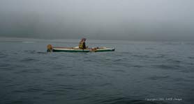
Next morning the wind had died but the woods and
water were shrouded in fog. As we struck camp Nibi
and I each went over to bid Herb farewell. I shook
his hand and said, "Hope to see you again in
the wilderness." To which he replied with a smile,
" Hahaha, if I live." I thought it was paddlers
black humor, but perhaps Herb had a premonition. As
Nibi and I cautiously creeped down the hidden coast
Herb bravely set an easterly course and paddled out
into the fog, without wearing his PFD. In short time
he had faded into the mists.
 |
Herb Pohl |
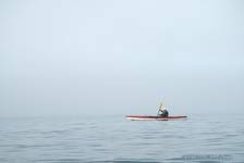
It was nerve wracking paddling blind in the fog.
Thankfully the wind and waves were managable, but
traveling for miles with such limited visability wore
on me. My GPS had malfunctioned, showing a black screen.
We used dead reckoning and often didn't know exactly
where we were on the map. Following an easterly course
we tried to stay off the rocks and shoals which frequently
extended far out into the lake. Occasionally a swell
would cross a submerged shelf and a white breaker
would rise, growling at us. I was reminded of the
old map notations, "Beware, here lie Dragons
".
 |
Foggy waters |
We traveled all morning in building swells and fog
and by late afternoon the lake had us rocking and
rolling. Again there was no place to pull off and
we had to paddle at least a quarter to half mile out
to avoid reflection waves. Mid day found us in Ganley
Harbor which unexpectedly was fog free. I had read
Ganley Harbor was an ancient native spiritual area.
It is guarded by a high broken red granite cliff and
there are Pukaskwa Pits there. Whether geographical,
meteorlogical or spiritual, we were thankful for the
brief respite of clear skies and bright sun. A sailboat
was anchored in the back and as we ate lunch under
a balsam pine a couple paddled up in kayaks to see
if we needed anything. Nice folks those sailboaters.
After lunch we continued, and eventually made camp
at a scenic spot called "Petit Mort Rocks".
A channel is formed by a string of islands and we
camped in the shelter of their lee. The early afternoon
stop meant we could swim, wash clothes and organize
our gear. Late that night a storm came through with
thunder, lightning and rain.
Day 7, 9 miles
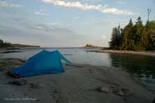 |
Petit Mort campsite |
Morning dawned overcast with warm, calm conditions
and we got a late, lazy start. By midday the calm
oily water changed to wind and bright sun. Again we
had headwinds with 2' waves, chop and an occasional
3' swell. We paddled for miles without seeing any
takeouts, the coastline rough rock cliffs and shoals
with crashing white water. One thought kept running
through my mind, "This is wild". Late afternoon
found us landing at the mouth of the Ghost River,
on a long exposed beach called The Flats. The weather
radio was calling for wind 20 to 30 knots and waves
over a meter and a half. We pulled our canoes high
up on the beach, battened down our tents that night
and prepared for a siege.
Day 8, 12 miles.
 |
windbound on
the Flats, Cliffs of Isacor in distance |
The next morning we were windbound. With line after
line of whitecaps, and wind in excess of 20 knots,
it would have been foolish to attempt travel. Besides
the next six miles traverse the Cliffs of Isacor,
and again there are no safe takeouts along that reach.
We needed calm conditions for making a crossing and
so we spent the day washing clothes, resting, eating,
taking pictures and exploring. The NSA kayakers caught
up with us that evening, surfing two foot waves into
the beach at sunset. They had waited at Floating Heart
Bay all day for conditions to improve. An hour before
sunset their guide, Jason, convinced them it was safe
to continue. With the wind at their backs, they had
paddled and surfed 4 miles in under an hour. Everyone
was excited and relieved to be off the lake.
Day 9 zero miles.
The next morning I was up at 4:30. By 5 we could
see the kayakers paddling out under headlamps. Man,
Jason really wanted to get a head start. We had been
checking the weather report everyday and today heard
a red and white kayak was found floating in Michipicoten
Harbor, all boaters were to be on the look out for
a lost paddler. Since Michipicoten was at the end
of our trip and still several days away we didn't
pay much attention. We both figured it was some daytripper
that hadn't tied his kayak down in the blow.
 |
The Cliffs of
Isacor |
The early morning calm made the lake smooth as glass,
in opposition to the fury that raged yesterday. The
Cliffs of Isacor were almost anti-climatic as we paddled
past them with no problems. In 2 hours we reached
the safety of Tamarack Bay. Throughout the day we
enjoyed light and variable winds with nothing more
exciting than local chop. A helicopter flew directly
overhead, heading east down the coast. By late afternoon
we were at the mouth of Dog River and found the NSA
kayakers already encamped. They said the helicopter
had actually landed on the huge gravel bar and asked
if they had seen a kayaker in a red and white boat.
They hadn't, but I remembered Herb Pohl, wasn't his
decked canoe red and white? Nibi and I paddled 1/2
mile back along the shore to a deserted cove to set
our camp. There Nibi checked his camera and sure enough
had a picutre of Herb paddling off into the fog, in
a red and white decked canoe. We discussed our concerns
about Herb. I made a VHF call to the Coast Guard but
got no solid answers from them. Only that the search
had been turned over to the local police. That afternoon
in force 3 winds I got to sail a little, beating out
into the lake and running back to the beach several
times. At least I can say I sailed Lake Superior!
Day 10, 10 miles
The next morning I had a rest day scheduled at Dog
River so we got up late. Dennison Falls are three
miles upstream and I wanted to pay a visit. In case
the weather turned bad we moved our tents to the mouth
of the river. The kayakers had already moved on. Our
hike to Dennison Falls wasn't a piece of cake. Somewhere
I had read (misundestood?) that you could paddle right
up to the lower falls. But as we got further up the
canyon we could see the river was blocked by rapids,
CII-III whitewater. Tying our canoes off in an eddy
we started hiking up the riverside, fording the knee
deep river in a couple of spots. Soon the cliffs on
each side pinched in blocking our progress, unless
we wanted to swim. Spying what looked like a slide
leading up. I scrambled up the slippery slope and
found a good trail about 100 feet above the river.
Following the trail another 45 minutes we came on
the lower falls.
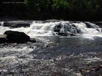 |
The lower falls |
The lower falls are about 10' high but the major
attraction is around the corner. To reach Dennison
Falls we had to scale a 30' rock cliff to the upper
trail. Whitewater kayakers come down the river every
spring and leave a knotted rope hanging in this spot.
I was sure the rope was replaced yearly but it felt
shaky trusting a manky looking piece of 3/8"
green poly. Upon reaching the upper trail a short
walk led to the main show. Dennison Falls is a multi
cascade dropping over 350' in a series of ledges.
The sound was deafening and the mist from the falls
drifted across the drop pool to the rocks below. We
ate lunch and Nibi spent an hour snapping pictures.
We then headed back to camp arriving late afternoon
footsore and tired, but happy we made the detour.
That evening a SSW wind rose and we listened all night
to the lake pounding the gravel bar.
Day 11, zero miles
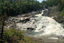 |
Dennison Falls |
The next morning dawned overcast with variable wind
and 2' waves. The forecast called for SW wind 10-15
knots and waves to a meter. Irregardless, we had to
move when possible even if only a few miles. After
waiting until 10:30 we decided to push on. Large breaking
waves at the mouth of the River made getting out tough.
By 11 the fog came in and visibility dropped to 20'.
Again there were no safe landings and the one meter
waves were crashing against the rock shoreline. We
paddled 1/2 mile out, straining to see the shore and
the reefs ahead. By late afternoon the fog cleared
and 3-4 foot swells started coming off the stern .
It felt like we were riding a rollercoaster as each
wave passed under the canoe, up and down. At times
we lost each other in the troughs. Finally, we saw
a beautiful 1/2 mile strand of sand in a bay and surfed
the waves in for a much needed break.
 |
fog paddle |
It was mid afternoon, still early. I wanted to try
and make 2 more miles to Minnekona Point for our final
campsite and to be in good position on our last day
of paddling. We waited an hour or so and the waves
looked different to me. Besides, one more hour rocking
and rolling with the swells passing under helping
sweep us on wouldn't be too bad. I got Nibi to agree
for a final push and we fought our way out through
the breaking waves. Once out the swells were still
from the SW but the 10-15 knot wind had shifted to
the NW and was pushing us out to sea. Between that
and the conflicted chop I felt very uneasy. With every
gust I had to hunker down and try to reduce my windage.
This wasn't good. I signaled Nibi to exit at the first
opportunity.
 |
The good beach |
We made a surf landing on the next sloping beach.
It was smaller than the last one, and covered with
gravel instead of fine sand and worst of all was inhabited
with flies! I asked Nibi if he wanted to try and paddle
back to the good beach, he declined. Thanks to me
we had traded an ideal campsite for a bug ridden sloping
gravel pit. Our last night out and we had to endure
a less than perfect bivouac. Oh, well, I started clearing
a level pad for my tent.
Day 12, 8 miles
 |
surf landing |
Our last morning was clear with light variable NE
winds. We were up at 5 and on the water by 7. We had
8 miles to the take out at NSA. The early morning
smooth water made for easy paddling. While Nibi followed
the coast I stayed outside, making a 5 mile crossing
from Dora Point to Perkwakwia Point. There Nibi and
I rejoined for the final 3 mile crossing of Michipicoten
Harbor. We remembered the wild frothing wavetrains
of a few weeks ago but this morning the harbor was
smooth and benign. We picked a low spot on the horizon
that looked like it might be the mouth of the Michipicoten
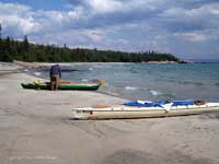
River and went for it. By 12 noon we landed at Naturally
Superior Adventures beach and had a small celebration.
Day 13, 8 miles.
 |
The NSA lodge |
We asked the people at NSA about the missing kayaker
and were told Herb Pohl's body was found in shallow
water just outside the river mouth, within sight of
the finish. Larry and I were shocked and saddened
to hear such bad news. It was later, after returning
home we learned Herb was a famous Canadian explorer,
a wilderness veteran with many crossings of remote
lands, and decents of wild rivers.
We dedicate our Pukaskwa Adventure to the adventurous
spirit of Herb Pohl, may he rest in peace.
 |
Hoz and Nibi
Mocs |
For more information about Herb Pohl,
https://nebula.on.ca/hamiltonassoc/h_pohl.htm
https://www.wildernesscanoe.ca/news.htm
Before leaving NSA we took one last look at Lake
Superior. In 2 hours the wind had changed and Michipicoten
Bay was again frothing with wave after wave.
The Pukaskwa Coast is a beautiful, wild and forbidding
landscape. Conditions on the lake can change quickly.
Before paddling Lake Superior be sure of your skills.
Carry a VHF radio, help or rescue could be days away.
For information, planning and logistics and shuttles
contact Naturally Superior Adventures, https://www.naturallysuperior.com/
Boat marina and shuttles (vehicle and boat pickup)
Bucks Marina, Wawa Ontario, Ca. https://www.bucksmarina.com/aboutUs.asp
Canadian topographical maps 1:50,000 scale
42D/9, 42D/8, 42D/1, 42C/4, 41N/13, 41N/14, 41N/15

|