Inspired by Richard Donovan’s “Paddling the Wild Neches” (Texas A&M Press, ‘06) my cousin David Felder and I decided to make a float trip down that river. He grew up in Cherokee County, Texas, on a farm which lay on a ridgeline looking west out over the Neches Valley. His mother and my father were brother and sister, both fished the Neches all their lives, and David and I spent a good bit of time on that river when we were kids.
Donovan made his float trip in a canoe, and we initially decided we would also use canoes. I went as far as to purchase two fairly large ones. But as we talked it over and began to formalize our plans we realized that although he had some experience in canoes he still didn’t consider himself very skilled in their use and I didn’t have much confidence in his ability to make such a trip safely, and that I had no experience in canoes and zero confidence in my ability to even get in and out of one safely, much less paddle down a swiftly flowing river full of brush, snags, whirlpools and boils. But both of us have spent years in flat-bottomed aluminum john boats, so we decided to take his fourteen footer. I bought a little four-horse Yamaha four stroke. Our confidence soared.
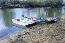 |
David's 14 ft boat with General Houston, the Pack mule boat, lashed alongside.
click images for larger views |
We met in Crockett on a Monday afternoon, bought a few more groceries, and camped that night at the state park at Weches. That’s the place where in 1690 the Spaniards built the very first deliberately established mission in what would become Texas. It was called San Francisco de los Tejas after one of the tribes of Southern Caddoan people who inhabited the area. The name ‘Tejas’ later came to refer to the entire province and is the origin of the name of the State of Texas. The Neches also derived its name from one of those tribes, and was given the name by Alonso DeLeon, the Spanish Governor of Coahuila, who made several trips to the area in the 1680’s.
My cousin David is a great guy, and has always been not just one of my favorite relatives but one of my favorite people. He’s honest, open, forthright, totally without pretense, and the kind of fellow who would literally give you the shirt off his back. He’s only about 7 years older than I am, but when I was a kid he seemed almost grownup, and had a .22 semi-automatic rifle he’d let me shoot sometimes. But he isn’t really into traveling light. His idea of camping is to hook a fifth-wheeler to an F-250. He brought a lot of stuff. He brought a tent that eight people could have slept in. It probably weighed about forty pounds. He brought a couple of big folding canvas chairs, an air mattress, a propane stove and lantern, three guns, a limb saw, a small chain saw, and two quarts of whiskey. I brought three cases of beer. We had two coolers full of ice for the beer, our cooking and kitchen gear, probably twenty pounds of canned goods, plus our bedding, extra clothes, and two tarps. We’d planned to be on the river for five days and had the supplies to do it. So as we began to load up the next morning we realized we had way too much gear to haul in one boat.
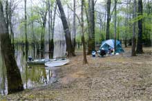
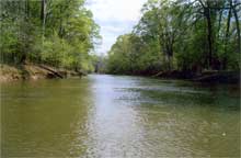
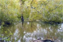
| Camp along the Neches. The high-water mark from the last flood is clearly visible. |
 |
One of the advantages of being from East Texas is that most of us have cousins all over the place, and it happened that one of my cousins lives near where we planned to launch. I had given her one of my small boats a year or so earlier to use on her farm pond, a little eight foot dingy/pram/punt I’d named General Houston, and she was happy to let us borrow it. At the launch site, where hiway 294 between Elkhart and Alto crosses the river, we lashed General Houston to the side of David’s aluminum boat, loaded both boats with gear and food, and shoved off. One of David’s cousins drove the truck and the trailer back to his home in Lufkin.
So we were off. The river was high and fast. It wasn’t out of its banks, but was full right up to within a foot or so of the edge of the banks. Another foot of rise and it would have been out in the flood plain, as it frequently is. We kept the motor in gear at low throttle mainly to allow us to maintain steerage. . .the river did the work of carrying us along. David’s GPS showed we were making about 6 mph.
 |
 |
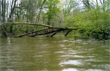
| Snags and strainers. You either go over, under, around or through 'em. |
In 1691 the Spanish explorer Diego Teran de los Rios described the Neches as a small river “difficult if not impossible to navigate.” The Southwest Paddlers guide to the Neches says “The Neches has steep, muddy, heavily wooded banks that make egress difficult to impossible in many areas.” The guide goes on to say the Neches “is a very twisting river with many sharp turns, log jams, strainers and dead-end channels.” It is also a relatively narrow river. There are places where it widens out and places where it runs more or less straight. But for the most part it writhes, twists and turns, and is seldom more than forty or fifty feet wide bank to bank. Most of the countryside it runs through is dense forest. The image of Texas in much of the world is of the wide open plains, but East Texas is woods, and the banks of the river are thick with huge pines and oaks. When these trees are finally undercut by the river and fall they can easily reach all the way across, and running the Neches is essentially a struggle to get around, over or under these dead falls, snags and brush thickets.
 |
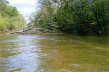
More snags and strainers. |
Most of the fallen trees only blocked parts of the river, and we were able to squeeze past, through or between trunks and limbs. Every so often we’d come to a place where we’d have to back off and study what lay ahead, find a likely spot, then ease down to it using the reverse gear on the motor to hold us off against the current, then work our way between limbs and under the trunk, sometimes having to practically lie down in the boat. All this was complicated by the presence of our pack mule boat, General Houston, which caused us to be wider than we should have been, and made steering a real challenge. And of course there were places where we went over fallen trees. Sometimes I was able to predict what was ahead, and lift the motor up, but several times we’d hit something solid and that little Yamaha would just about jump off the transom and into the boat with us. With the prop out of the water, of course, we had no steering, and I’d have to raise up, reach back and pull on the motor, lift the lever holding the motor up, and drop it back into place, sometimes while being rubbed by limbs and switched by branches, while David struggled to maintain some measure of control with his paddle. It was a hoot!
 |
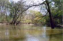 |
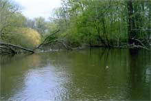
| Some stretches of the Neches are open and beautiful. Our slow pace allowed us to fully absorb the quiet beauty of the river. |
Then there would be long stretches of river that were more or less clear and open and those would lull us into a feeling of complacency. Since we were going downstream we mistakenly assumed that the river would become wider and clearer as we progressed, but that turned out not to be the case. Those stretches of river were splendid though, and at the sedate pace of our travel we were able to thoroughly absorb the beauty of what are some of the most remote and inaccessible woodlands in the state.
But early in the afternoon of the second day we came round a bend and there before us, from bank to bank, was a wall of pale fresh green. A recently fallen tree, judging from the fact that it was fully leafed out in spring foliage, lay across the river. We backed off, pulled out on the west bank, and surveyed the situation. Beyond the freshly fallen tree lay another, older fallen tree, and beyond it was what appeared to be more brush. The banks were steep and muddy, and the ground alongside the river was a swampy slough that would have made dragging the boat and our equipage up and over and around an extremely slippery affair. It was time to make a decision.
| the place where we realized the river had defeated us and where we began our retreat. |
 |
The next place where we could take out would be the bridge where hiway 7 between Crockett and Lufkin crosses the river. David had been tracking our position and knew exactly where we were, and it was less than a fourth of the distance between the last bridge we’d passed, the hiway 21 bridge, and the hiway 7 bridge. We looked at the meandering line on the topo map that represented the river and tried to imagine what we might encounter. We figured we could probably whittle our way through the tree that blocked our way, and probably the one just past it. But we also had to acknowledge the probability that there would be not only many more such places downriver, but that some of them were likely to be even worse, and perhaps impassable. We hadn’t really thought much about having to motor back upriver. Our engine was the little 4 stroke 4 horse Yamaha I’d bought specifically for this trip. We had most of a two gallon tank of gas, plus a gallon in a spare tank. That would be enough to get us back upriver from where we were, but if we went another ten or fifteen miles downriver and then were forced to retreat, would we have enough gas to make it against the strong current?
The realization that we were trumped slowly insinuated itself into our awareness. If we’d been youngsters with no responsibilities or obligations we might have pushed on anyway. But we’re old guys with wives and families. David has a grandchild. I have a daughter still in college. We agreed that the prudent thing to do was to retreat, to fall back in good order and live to fight another day. The question then became whether to make camp and spend another night along the river, or whether to try to motor back to the hiway 21 bridge and take out, and we decided to defer that decision until we could see how we did against the current. When David’s GPS indicated our speed upriver at about 3 mph with the throttle wide open we figured we could make the bridge, and the prospect of a hot bath, a real bed, and dinner in a café began to beckon and lure us onward. We made the bridge just before sunset, hauled out, and were picked up by David’scousin.
 |
 |
| Happy River Rats. |
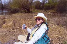
| David Felder |
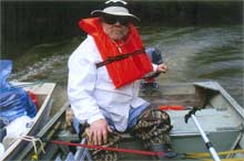
Tyson McLeod |
Ironically, the only time we lost any of our load was on the way back upriver. We came to a place where a big tree lay bank to bank, which on the way downstream we’d navigated through with some care. I saw a place where there were no big limbs hanging down, just a lot of thin branches, and I thought we could just power through, so I yelled for David to hold on to his hat and we ploughed into it. We got through with a lot of cracking and snapping, but a bag on top of the load was brushed into the river, along with the paddle David was using to try to fend off the larger branches. So we turned around, went back through, retrieved the paddle and the bag ( which contained David’s heavy jacket and his rain suit) which was floating merrily down the stream , then fought our way through the same spot one last time. We wound up with enough brush and sticks in the boat to have built a pretty good camp fire. One time going downriver I miscalculated an opening and ran General Houston square into a big ugly looking limb, thinking at the time it would surely either tear the pack boat away or smash the front of it. But with a great cracking crunch the end of the limb snapped off and a piece about two feet long fell into the boat.
In short, there were a lot of times and situations in which we asked ourselves why anybody with a lick of damn sense would consider doing what we were, at that moment, trying to do. And frankly, not only have I not yet come up with a good answer to that question, I’ve found myself studying maps of the place, thinking about it, wondering if maybe two guys in a different kind of boat, at a different time of year, with a different level of water, and more lightly equipped in most ways might be able to squeeze past, whittle and carve, portage, and eventually make it through. I’ll be sure and let you know. |