
 Custom Search
|
| sails |
| plans |
| epoxy |
| rope/line |
| hardware |
| canoe/kayak |
| sailmaking |
| materials |
| models |
| media |
| tools |
| gear |

| join |
| home |
| indexes |
| classifieds |
| calendar |
| archives |
| about |
| links |
| Join Duckworks Get free newsletter CLICK HERE |
|
|
| The Everglades Challenge - 2013 |
by Gary Blankenship
- Talahassee, Florida - USA with comments in italics by Chuck Leinweber |
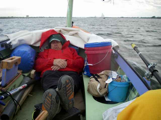
| Part 1: Start part 2 - part 3 - part 4 - part 5 It's 3 a. m. and cloudy. A light but steady rain is falling on the boom tent stretched over the cockpit. The main and mizzen masts, with their furled sails, form the ridgepole. The tent keeps the rain out, but water still drops from the sails, which were exposed to the rain for a couple hours before the boat was anchored for the night in a few inches of water, after a hard day of sailing in brisk winds. The temperature is heading toward the mid-40s. The boat has been sponged out, but everything is damp at best. A dodger keeps the drips off one crew, but the other is exposed to the intermittent Chinese water torture. Neither can fully stretch out. Sleeping bags have been left stowed rather than risk getting them wet on the first night of a multi-day trip. The crew are in long underwear, fleece, and foul weather gear, padded with boat cushions and a thin closed-cell pad. Your reaction to these conditions is: A) The rain lightly drumming on the tent is a great sound. B) What the *$&^$@ am I doing here? If you're answer is A, you may be suitable to an Everglades Challenge. Chuck Leinweber and I were in this position after the first day of this year's 300-mile challenge. I think Chuck had the first reaction; I know I did. But then, I was the guy under the dodger.
For the uninitiated, the Everglades Challenge is a 300-mile, unsupported expedition event for kayaks, canoes, small sailboats and other such craft. (A stand-up paddle board completed the course this year, as well as a rowing boat, a first for both types.) The start is in Tampa Bay, and crews must beach launch their vessels from above the high tide mark. The finish is 270 to 300 miles away (depending on the route taken) in Key Largo, with three mandatory checkpoints in between. Competitors are divided into six classes; we were in Class 4 for monohull sailboats. We all also have nicknames. Chuck is Chuck the Duck. I'm Lugnut. For complete details, routes, and rules, go to Watertribe. org.
Chuck had gone with me in 2006 on my first completed EC, with my Jim Michalak Frolic2 design, Oaracle. Since then, Oaracle and I had finished another four of the five ECs we had entered, including one singlehanded finish. In 2006, Chuck exacted a promise that I would go with him when he finished his John Welsford Walkabout design. Walkabout is a 16-footer designed for single-handed coastal expeditions and Chuck stretched it two feet, with Welsford's blessing, to make it more suitable for two.
Construction proceeded sporadically interspersed with assemblage of new kayaks and such, but last year it was finally done and Chuck successfully ran the Texas 200, turning in a good time. Shortly thereafter, he informed me he would be collecting on the promise for the 2013 EC. (And you thought pressing of sailboat crews went out with the War of 1812.)
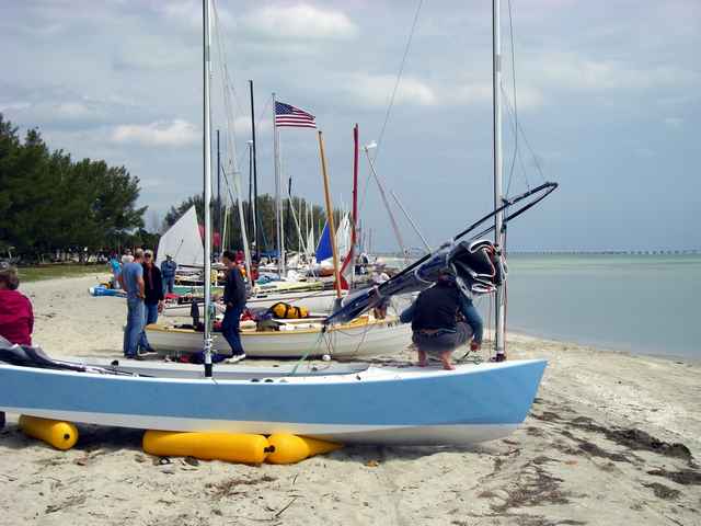
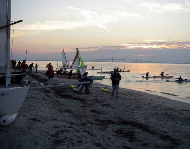
And so it was that in the predawn hours of March 2, we were on the beach (along with 89 other EC boats and 16 in the shorter Ultra Marathon) at the lovely Ft. Desoto Park, south of St. Petersburg, wondering what happened to the predicted 20 knots of northwest wind promised by the weather forecast. What we had instead was an uncertain riffling from the east-northeast.
At least that was the uncertainty for most of the competitors. Our uncertainty centered on the location of Chuck's boots. This was no small matter as with the proper socks he can wade and get his feet wet and these boots will keep those nether extremities warm. So while other boats launched and I did some videoing, Chuck searched frantically. They were finally located a short distance away, near the grass. Apparently we had placed them in our pile of gear the previous day when unloading supplies on the beach and loaded everything else but the boots, which spent a forlorn night waiting to be noticed.
(The episode with the boots was no real loss in starting, as the wind used the time to fill in to a decent velocity, but from the northeast, not northwest. But it was not an encouraging beginning. We had adopted the informal motto that we were two half wits out to make a whole. The lost boots indicated that as yet there was no knitting of the wits.) We finally hit the water about 20 minutes after the start. Most others had left, but we were a long way from the last off, at least. The wind, which had increased enough that we decided to put in a precautionary reef, pulled the boat from the shore after we rolled it to the water. As Chuck was getting ready to steer and I was trying to hold it back. I wound up making a rather ungainly head first dive into the boat as the wind won the tug of war, and hoped no one was videoing. Out of respect for the expected wind, we elected to proceed down the Gulf Intracoastal Waterway instead of going outside into the Gulf of Mexico. We had a lumpy ride across Tampa Bay, but the wind held and we passed under the first two bridges. It was a time to be thankful for the Walkabout's balanced lug main, which has a roughly 16 to 17 foot bridge clearance, a marked advantage over most of the Bermudan rigged sailboats in the fleet. The wind eased (we unreefed and Chuck rowed a bit at its nadir) and then, as predicted, shifted to the northwest and began to blow in earnest as we passed the Longboat Key inlet and entered northern Sarasota Bay. We pulled up to an island to furl the mizzen, put a reef back in the main, and get ready.
Sarasota Bay churned us south and the waves rapidly picked up. When a following wave caught the Walkabout just right, the boat would overtake the waves in front of it. We watched as the GPS regularly surged over eight and nine miles per hour and once sped past 10. Yet the boat, also as promised by Chuck, remained easy to control; I had been worried about following seas picking up the stern and slinging it around. Our Spot satellite tracker, which reported every 10 or 20 minutes, never recorded less than a 6 knot average during this stretch and peaked at nearly 7. (Pardon the switching in speed measurements here; one of our GPS units and the Spot read out in knots, the other GPS in mph. One knot equals about 1.15 mph.) Quite an average for an 18 foot boat - well above theoretical hull speed. We slipped by Watertribe founder Steve Isaac (Chief) in his new Hobie Adventure Island, with the sail mostly rolled up, about halfway down the bay.
This video shows what Sarasota bay was like: Shortly before 1 p. m. we rollicked under the first Sarasota bridge, getting close enough for a chat with veteran Watertriber Nick Hall (Pelican) in a Hobie Tandem Island with his nephew Mark, (Falcon). But after the Siesta Key bridge, the ICW narrowed and occasionally the wind was partially blocked, and Nick pulled away. Not that we were lonely. We always had some kayaks in sight as we went down the bays and canals, and could see three or four sailboats in front of us as we approached the Blackburn Bridge, a nine-foot clearance swing bridge obstructing the channel. But we got lucky. We were too far beyond the boats in front of us to expect the bridge to remain open when it swung out of our way. But when I called the bridgetender to inquire, possibly with a forlorn tinge in my voice, how long we would have to wait for a reopening, she said she was holding the bridge open for a northbound powerboat waiting for the sailboats to clear and she would continue holding the bridge for us. So we caboosed through courtesy of the kindly bridgetender and our fellow ECers. Our speed had slowed slightly, but we still averaged 5.5 to 6 knots.
Around 3:40, we approached Venice Inlet and Neil Calore (Leather Lungs) in his 17-foot CLC dory, and we turned at the inlet and headed east for the canal leading to Lemon Bay. In the high banked canal, the still strong wind went fluky a couple times and we briefly broke out the oars to help out. Despite that, we couldn't slip by Neil and he led us into Lemon Bay around 5:30. We took special care to stay in the ICW as the daylight faded and our speed continued to be around 5.5 knots. There are many unlit signs and private markers outside the channel.
This clip shows us going under a bridge just before the Venice Canal
As we approached the southern end of Lemon Bay in the last of the light, we finally passed Neil when he rounded up to make a sail adjustment. The waterway narrowed into a channel which blocked the now easing wind. We dropped the sail and cautiously poked our way into Cape Haze Marina, the new first checkpoint for this year's EC. We arrived at the dock and hit the OK button on the Spot at 7:47 pm.
We took a couple hours to stretch, have some hot soup, chat with fellow competitors and the checkpoint crew, eat a little more, and add warm clothes for the predicted cold night. Then we pushed off and headed back to the ICW. The forecast was for northwest winds at 20, easing to the north and dropping to 10 to 15 later. We figured we could make good time to and through Pine Island Sound and then, taking turns sleeping and steering, head down the gulf coast. So much for the plans. The wind wasn't blowing at 20. Or 15. Or 10. Or even a measly 5. It was gone. At first we figured it was blocked in the in the narrow channel. But the wind stayed absent when we hit more open water. There were several good camping options, including a state park, near the checkpoint, but we hadn't set waypoints or marked any of them. Our combined wit kept assuring us we wouldn't be abandoned by the wind for long on a night when the weather radio assured us of strong breezes. So instead of being warm in a tent and bedrolls, we took turns rowing and did the Gasparilla two-step with the Gasparilla swing bridge. The bridgetender acknowledged our initial radio call, which included informing him we were under oar power. He then proceeded to open the bridge long before we could get there, and then close it again as we finally approached. Another radio call straightened things out, although we had to wait a couple minutes for the reopening. It began to rain - no real hardship as we were in foul weather gear - and we pulled through the old railroad bridge. It now occurred to us we were likely to be without wind for quite some time and rowing all night would only tire us out for the following day. But there was also a dearth of suitable camping or anchoring sites, so we wound up rowing to Sandfly Key at Charlotte Harbor, eight miles from the checkpoint and where we anchored in shallow water. We couldn't find a suitable beach for pitching the tent. And for the charms of sleeping under a boom tent in the rain, see the start of this article. . . . Next time: Day 2 Here is a video montage with clips from the entire EC: |
|