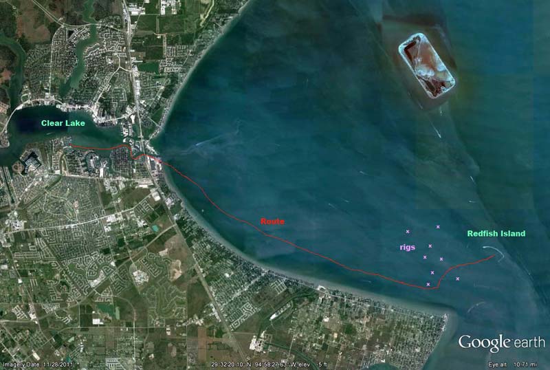
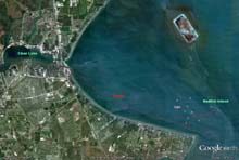
| I got a wild hare the other night, after a great day of sailing with the family, and decided I wanted to spend the night out at Redfish Island. This is a little man made arch of dredge material and cover rocks the Army Corps built to replace the "original" island that the tanker wakes destroyed years ago. Below are a Google Earth picture of Clear Lake and Redfish Island. For reference, it's about 9 miles from my marina to Redfish Island, and about 15 miles south to Galveston.
 |
It might seem a bit odd to some of my northern friends that Dec. 18th would be a good time to sail at night to an island for an "anchor out", but this is TEXAS! :-) It was 75 degrees that day, and the low was only 60. But being mid December, one fact that doesn't change with the weather is the very short days! Leaving at 7PM I was already in the dark! Now I've sailed on Galveston Bay many times in the dark, but I usually stick to the very large area outside Kemah that has no rigs. The bay is strewn with old oil and gas rigs, many are damaged and abandoned, and not all are lit. This began to weigh heavily on my mind as I got further into the Bay.
To avoid the majority of the rigs I headed south, over to the San Leon area and Eagle Point, and stayed just off the coast, riding a sweet South wind and enjoying the smooth water that the windward shore afforded me. By 9PM I was nearing the island, and several rigs that were between me and my anchorage. Most obstructions are labeled on the charts, but the operative word is "most"! Watching the GPS, charts, and horizon....alone, in the dark...with the ship channel just beyond, and all the lights that come along with that, it was a nervous time! There is one rig I remembered was very low and wide, covering maybe 150 feet but just above the water. I was glad to finally see that one, and to see it had a light!
Once past the rigs I had open water; another 30 minutes and I would be there. I was now out of the protection of Eagle Point, and parallel to an increasing south wind. With the very long fetch I was exposed to large bay chop and the ride was a bit rough. Being on a big cat it wasn't really an issue. I trimmed sail for a nice reach (which is an interesting trim scheme on a biplane rig) and sat back for the ride.
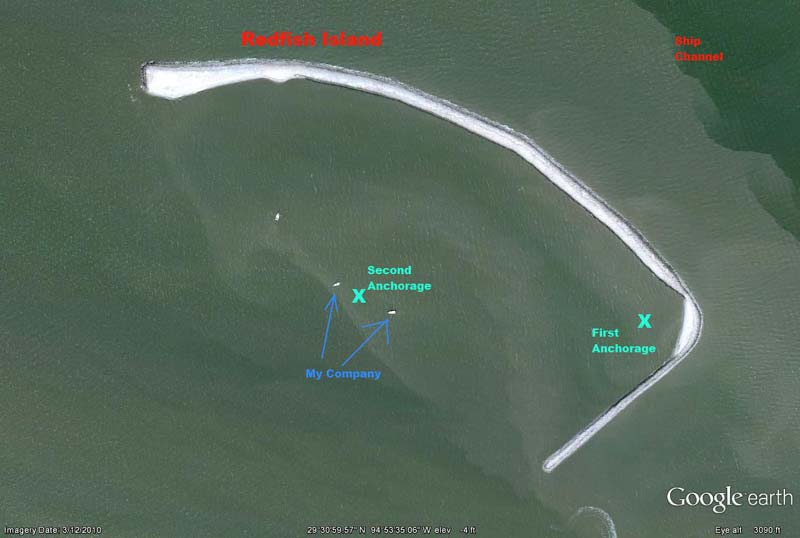
Arriving at the island I headed as far into the SE corner as I dared in the dark to try to get some protection from the strong south wind and heavy chop. As soon as I found some smoother water I dropped sail and when the boat stopped I lowered my already-prepared anchor. The water was shallow, maybe 5 feet, so I put out about 50 feet of rode. Despite the relatively smooth water, the low island did nothing to block the wind, and El Gato Gordo has no shortage of windage! After the anchor seemed to be set, I began to prepare a dinner of reheated chili and a cold Red Stripe. I was watching both my GPS position and the lights around me, and before long I knew the anchor was dragging. The Danforth anchor had held in worse conditions, and most of the bay has deep nasty mud, so I was surprised at the situation...not to mention spooked about dragging into the island into the dark.
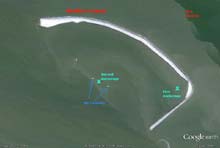
Here I am...it's pitch dark, I'm in a really light boat with tons of windage, surrounded on 3 sides with rocky shore, and rigs on the third (ok the rigs are a ways away)...to say the least I was worried! When I'm at home and need some information, I turn to Mr. Google. Being within cell range, I decided to use the same source of help! Google Earth is a source we often use while planning, but having looked at Redfish Island on GE many times, I knew one thing: The picture on GE shows several boats anchored..and I wanted some company! My plan was simple, anchor where they were anchored when the picture was taken. After recovering the anchor I motored about 150 yards north west to where the 2 biggest boats were, and again set the anchor. Now at least I wasn't alone (at least not on my phone's screen ;-)
By now it was about 11, and dinner was reheated and eaten...as well as a couple beers downed...and it was bed time! One thing I haven't done much is sleeping on a boat at anchor. Most of the time I've been pulled up on a beach, with an anchor in the sand for peace of mind. To keep track of my position I used 3 landmarks: 2 brighter lights to the east and north, and a tower to the west. I also had an Android app I just downloaded a few weeks ago called Drag Queen, essentially a phone based anchor alarm. This app uses the phone's (or tablet's) GPS and alarms when you are a preset distance from the mark you set. Although I've tested it a lot, I just can't get myself to trust it completely. It also uses a lot of power, but I suspect it's less than a full blown chart plotter would. But since I would keep my phone on anyway, it makes sense for me.
The new location seemed to allow the anchor to set well and I never had cause to think I was dragging again all night. The problem was....this new location was now outside the protection of the island! This is a very popular anchorage in the Galveston/Clear Lake area, and well known for its protection...but we usually have a SE wind, rarely just South, and I was now in the full force of the swell and wind. The good news was the wind was slowly decreasing, and though it was noisy, the catamaran stayed flat and dry. But I wasn't as comfortable as I would like, and really I just caught cat naps all night, getting up every 10 or 15 minutes to verify my location.
 |
Despite not sleeping much, I enjoyed the sounds around me, the closeness of the water, and looking about as the marine traffic continued through the night. The Houston ship channel is right on the other side of the island, and watching the huge ships and constant flow of tows has always been fun to me. The sound of wakes crashing against the island, the distant fog buoy, the strong wind, the roosting birds disturbed by some unseen irritant...all combined into a nautical symphony that kept me entertained throughout the night.
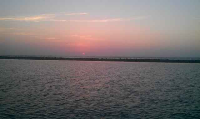
Twilight broke beautifully over the East Bay, and all the scary sounds and the menacing black island were chased away by its dim orange glow.
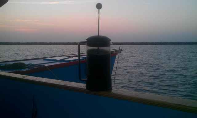
Now that the early dawn light made it easy to tell where the smooth water was and I would clearly see if I was too close to the rocks, I moved back into the lee of the island, anchoring just 50 yards off, and prepared to get some more sleep. As these things often go, the beautiful morning, and all the sights and sounds that came with it, conspired to wake me up and sleep was not to be had. I've learned to love my French Press (Thanks Cathy!!), and this morning, against the rising sun, the dark coffee was the best I've ever had.
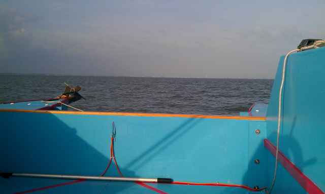
A fast breakfast was next up, as well as bringing order back to El Gato's sizable decks. The wind was still southerly, but much lighter now, the water much smoother, and I couldn't stay put any longer! I had a lovely (and intentionally slow) sail back to Clear Lake, and back to reality; this adventure was now a memory.
*****
|